© Copyright 2020 - Suburban Adventures - All maps/resources freely available on a Creative Commons basis

Permanent Courses

A series of permanent courses is available.

These can be used for navigation training/outdoor
activities by local families and Scout Groups
or use them to improve fitness and practise your navigation skills 

If you haven't used MapRun before, try it out on one of these courses.

Instructions for Use

  1. ORIENTATION - maps are usually oriented so that North is at the top of the page. To find north, extend your left arm so that it points to the setting sun. If so, you are facing North.
  2. MAP SCALE - check out the scale; joeys move at 15 minutes per km. Scouts will walk at 12 minutes/km or run at 7-8 minutes/km
  3. OPEN MAPRUN - Assuming you have MapRun installed and set up.....the main screen is displayed.
  4. SELECT AN EVENT - To select your event, you can press Events Near Me and pick one or Select Event and use the directions on the map (and below)
  5. START THE COURSE - press Go to Start. A red dot is displayed on a map. The dot is you, the triangle is the start. Walk towards the start. As you approach the start, the phone beeps and displays S1 punched.
  6. GO TO CONTROLS - the phone should beep at each control. If not, check that you're in the right location. If you're sure of where you are, just move along and report it at the finish.
  7. AT THE FINISH - you can press Show Results to see your results and that of others. If you press the Track button, it will display the track for that runner.

Maps Available

Choose the course you want and then click on the map to download a PDF copy

MAP                                                       SUBURB                                        DIFFICULTY
Bellbird DellVermontModerateDownload Map
Box Hill NorthBox Hill NorthEasyDownload Map
Macleay ParkBalwyn NorthEasyDownload Map
Valley ReserveMount WaverleyModerateDownload Map
Quarries ParkClifton HillModerateDownload Map
Ferndale ParkGlen IrisEasyDownload Map
Blacks WalkBlackburnEasyDownload Map
Wattle ParkGlen IrisEasyDownload Map
Westerfolds ParkGlen IrisEasyDownload Map
Jells ParkGlen IrisEasyDownload Map
HeatherdaleGlen IrisEasyDownload Map
Ferndale Park - Cub CourseGlen IrisCub CourseDownload Map
Knaith Road ReserveRingwood EastCub CourseDownload Map
2/7th West Waverley Treasure HuntAshwoodStreet CourseDownload Map

Bellbird Dell

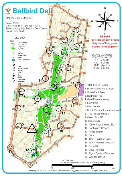
A very pretty, linear park approximately 1.4 km in length. A little care is required if doing control 18 - there is a grass verge, but no footpath.

MapRun Information

Press Select Event
Go to Victoria > RunFree > SAR
Select Bellbird Dell Course - Junior, Adult Walk or Adult Run
Press Go to Start - the start is the Fence Corner next to the Northern Gate

Course Notes

Course Difficulty : Moderate
Course Length (all controls): 5-6 km
Click on the map to left to download a PDF copy


Box Hill North

An area with reasonably quiet urban roads. There is a shopping centre in the SE corner of the map.

MapRun Information

Press Select Event
Go to Victoria > RunFree > SAR
Select Box Hill North Course - Junior, Adult Walk or Adult Run
Press Go to Start - the start is the Pine Log Fence just East of the playground

Course Notes

Course Difficulty : Easy
Course Length (all controls): 6 km
Click on the map to left to download a PDF copy


Macleay Park

Local sports fields interspersed with reasonably quiet urban roads. 

MapRun Information

Press Select Event
Go to Victoria > RunFree > SAR
Select Macleay Park Course - Junior, Adult Walk or Adult Run
Press Go to Start - the start is a small tree behind the scout hall.

Course Notes

Course Difficulty : Easy
Course Length (all controls): 5 km (?)
Click on the map to left to download a PDF copy


Valley Reserve

One of the best bushland reserves in Melbourne. Features BBQs, shelters, toilets and a huge adventure playground.

MapRun Information

Press Select Event
Go to Victoria > RunFree > SAR
Select Valley Reserve Course - Junior, Adult Walk or Adult Run
Press Go to Start - the start is the end of a track that leads through the trees into the open ground East of the Scout hall.

Course Notes

Course Difficulty : Moderate
Course Length :
      - Juniors/Walkers - Score Course - 3-4 km
      - Runners - Line Course - 6.5 km
Click on the map to left to download a PDF copy


Quarries Park

A delightful area just West of Yarra Bend. This course covers the park area adjacent to the Merri Creek and a little of the Yarra Bend area on either side of the freeway.

MapRun Information

Press Select Event
Go to Victoria > RunFree > Scouts
Select Quarry Park Course - Junior, Adult Walk or Adult Run
Press Go to Start

Course Notes

Start/Finish - Light pole at Southern corner of playing field
Toilets available nearby
Great coffee shops in Ramsden Street
Click on the map to left to download a PDF copy

Make a site - Details here